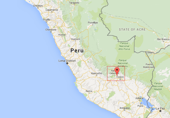
Then finally it was time to check off one of the most anticipated items on our itinerary: Machu Picchu. As you might imagine, it’s a bit of an ordeal to reach the remote former Incan capital. From Cusco, we had to take a one-and-a-half hour minibus to one of the main hubs, tiny as it may be, of the Sacred Valley: Ollantaytambo (I knowwwwww, what a mouthful, right? Thankfully many people shorten it to “Ollanta,” which is how I learned to think of it more as “Ollanta. Y. Tambo.” #protips). From Ollanta, it’s a three hour train ride to the town of Machupicchu, more commonly known as Aguas Calientes (apparently so-called for an actual hot spring on the north side of town, but we never made it there).

touched-up google map of the route…
larger map for scale
If flying over the Andes into Cusco was spectacular, then riding the train through them to Aguas Calientes was… also very spectacular. We rode Peru Rail, with the other choice being Inca Rail. What’s the difference? I don’t know, but it sounds like this guy does. And as I confessed in my LA post, where I committed the same crime, I couldn’t help but take some photos through the scuffed up, glare-y windows.

coffee and coca tea. though machu picchu, and ollantaytambo even moreso, are lower altitude than cusco, we continued partaking of one of the preferred elevation-sickness remedies in peru.

there was sooooo much campaigning being done on the city walls everywhere we went! though this could possibly just be some love graffiti. HUMBERTO Y ELVIS POR SIEMPRE!

adding to the dogs-in-peru collection
Though taking a bus seems to be by far the more popular means of going from Aguas Calientes to Machu Picchu, we opted to hike. The bus ride may be only twenty minutes, but we were warned (and believed, as soon as we saw it) that the line to get on it could take up to an hour. As the hike was only supposed to be around an hour/hour-twenty itself, and the weather was so fantastic, we decided we might as well stretch our legs after the long train ride. It’s a steep (largely stair-bound) but easily-navigable trail; I’d definitely recommend it. Plus we saved $10! Each!

zoomed in on people up on huayna picchu

huayna picchu in the distance
(And the answer is… Yes, we’re both wearing the City Sports shirts we bought at the Chinatown store’s going-out-of-business-sale [*pours some out*]. I’ll let it be known here that Marlon had packed his overnight bag first, though I wasn’t aware of his choice when I packed mine. #coupletwinning!!!)
Before exploring the actual ruins of Machu Picchu, we decided to continue our ascent to the Sun Gate. (Which… ended up requiring another steep, hour-long hike. Whoops! Yeah, keep that in mind ahead of your bus-vs.-walking decision, I suppose…) The views and our weather were so phenomenal the entire time, but we could see that clouds were collecting in the distance, and were told that there were two storms about to converge basically right above our heads. Huayna Picchu, the even taller peak whence you get the absolute best views of Machu Picchu (but which is actually just dangerous to ascend at this point and so is about to get shut down for maintenance work), got evacuated. Ultimately we just ended getting sprinkled on ever-so-slightly at the very end, though.
Fun facts: though I’ve spent my whole life saying “mah-chu pee-chu” (and, let’s be honest, still totally say that), notice there is an extra “C” in “Picchu.” It’s really supposed to be said “peak-chu“! And also, while still magnificent, while still impressive, the ruins are actually much less old than I was thinking: the Incas built the city around 1450 and abandoned it about a century later. The Spanish conquerors never knew of its existence. (There, I’ve summed up the Wikipedia intro paragraph for you. Read further, if you care.)
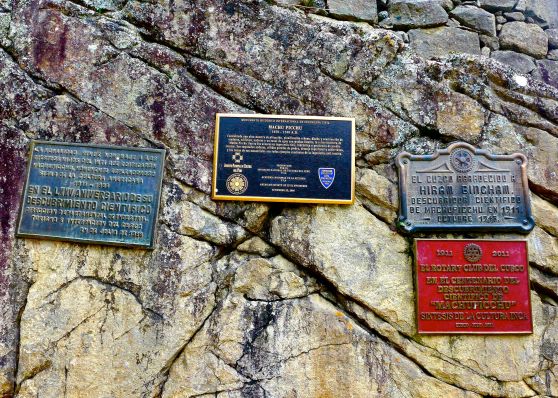
one more fun fact! hiram bingham, the man being commemorated in the top right plaque for [re-]discovering machu picchu in 1911, was the inspiration for indiana jones.

I GOT THIS FOR YOU.

LET’S EACH TAKE A SELFIE AT THE SAME TIME BUT ONLY LOOK AT OUR OWN CAMERA, OKAY?
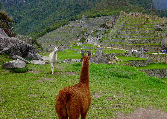
Oh right and there were llamas at the end.

SPOTTED.

HI!!!!!!!

‘hey, what do you think of this one?’
Omg somehow I forgot to include the RUNNING LLAMA GIF.
Then we did take the bus back down to Aguas Calientes (as opposed to walking). While waiting in line we chatted briefly with an Austrian couple who very assertively said that Arequipa was the most beautiful city they’d visited in Peru. And with that, we more-or-less got the last leg of our trip planned.
But first– the unplanned night in Aguas Calientes. (We had booking issues the day before, remember? And couldn’t get on a train back to Cusco the evening of our Machu Picchu visit? So were forced to stay a night in Aguas Calientes and take a very early train back to Cusco, by way of Ollantaytambo, the following morning?) We stayed at TripAdvisor-approved Hotel La Cabana Machu Picchu, and ate at the Fodor’s-guidebook-recommended Tree House Restaurant for dinner. I’m happy to pass on the recommendations in both cases! In fact, Aguas Calientes as a town surpassed my expectations (we’d been told it wasn’t worth staying at). It was a pretty quintessential backpacker town, in a beautiful location, with lots of good-but-affordable food and lodging choices. Definitely worth at least one night’s stay– next time, maybe the night before the Machu Picchu trek, so as to do the sunrise tour.


